Maxar Shows 3D Sat Video Of 40-Mi.-Long Russian Convoy

3D-video rendering of Russian military convoy stalled north of Kyiv.
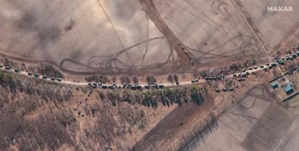
Credit: Video © 2022 Maxar Technologies (per Maxar’s request).

Maxar has generated a 3D video of a 40-mi.-long Russian military convoy stalled on a road north of Kyiv using its WorldView-3 satellite.

Video © 2022 Maxar Technologies.

The satellite company says the video was produced using more than 1,400 km2 of imagery collected by its satellite over the convoy area in a single orbital pass on Feb. 28. The video was released to the public five days later on March 4.

“This data has an absolute accuracy in all directions of 3 m, which means that objects seen in the video are physically within that 3-m zone in the real world,” the company said March 4. “This unique view, created with space-based data, allows viewers to have a better understanding of the on-the-ground situation when the area is not readily accessible.”

Maxar has released 2D images of the Earth’s surface for years, but is now promoting its Precision 3D Data Suite, which has several different types of 3D mapping data created by taking and combining Earth images from multiple angles.

“The video, which includes sections of the convoy but not the entire 40-mi. length, was created by geo-registering Maxar’s Feb. 28 WorldView-3 satellite imagery on top of its Precision3D model of the Kyiv area,” the company said.

Maxar sells much of its satellite image data for commercial applications, including to the agricultural, oil and gas, and mining industries. For example, its data is used by energy companies to create surface models of remote regions before geologists travel to conduct seismic surveys in search of oil and natural gas deposits deep underground.

But the company is also pitching services for the global defense industry and various militaries. For example, in October the firm announced that it had integrated its 3D-image data into the Saab Gripen, allowing the fighter jet to fly with image-based navigation in regions where GPS is jammed or spoofed, or in situations in which using terrain-following radar might give away the combat aircraft’s position. 
 

Garrett Reim

Based in the Seattle area, Garrett covers the space sector and advanced technologies that are shaping the future of aerospace and defense, including space startups, advanced air mobility and artificial intelligence.