https://ngtest.aviationweek.com/themes/custom/particle/dist/app-drupal/assets/awn-logo.svg
Skip to main content
  • Market Sector
    • Aerospace
    • Air Transport
    • MRO
    • Defense and Space
    • Business Aviation
  • Markets
    • Aerospace
      • Aircraft & Propulsion
      • Connected Aerospace
      • Emerging Technologies
      • Manufacturing & Supply Chain
      • Advanced Air Mobility
      • Commercial Space
      • Sustainability
    • Air Transport
      • Aircraft & Propulsion
      • Interiors & Connectivity
      • Airports & Networks
      • Airlines & Lessors
      • Safety, Ops & Regulation
      • Maintenance & Training
      • Sustainability
    • MRO
      • Aircraft & Propulsion
      • Interiors & Connectivity
      • Emerging Technologies
      • Supply Chain
      • Safety, Ops & Regulation
      • Workforce & Training
      • Sustainability
    • Defense and Space
      • Aircraft & Propulsion
      • Sensors & Electronic Warfare
      • Missile Defense & Weapons
      • Supply Chain
      • Budget, Policy & Operations
      • Space
      • Sustainability
    • Business Aviation
      • Aircraft & Propulsion
      • Interiors & Connectivity
      • Airports, FBOs & Suppliers
      • Flight Deck
      • Safety, Ops & Regulation
      • Maintenance & Training
      • Sustainability
  • Marketplace
  • Services
    • Services
      • Advertising
      • Marketing Services
      • Fleet, Data & APIs
      • Research & Consulting
      • Network and Route Planning
      • Marketplace
  • Store
    • Market Sector

      • Aerospace
      • Air Transport
      • MRO
      • Defense and Space
      • Business Aviation
    • Type View All Products
      • Intelligence Bundles
        • AWIN - Premium
        • AWIN - Aerospace and Defense
        • AWIN - Business Aviation
        • AWIN - Commercial Aviation
      • Market Briefings
        • Advanced Air Mobility Report - NEW!
        • Aerospace Daily & Defense Report
        • Aviation Daily
        • SpeedNews
        • The Weekly of Business Aviation
      • Directories
        • Air Charter Guide
        • Aviation Week Marketplace
        • Route Exchange
        • The Engine Yearbook
      • Data Services
        • AC-U-KWIK
        • Aircraft Bluebook
        • Airportdata.com
        • Airport Strategy and Marketing (ASM)
        • CAPA – Centre for Aviation
        • Fleet Discovery Civil
        • Fleet Discovery Military
        • Fleet & MRO Forecast
        • MRO Prospector
      • Publications
        • Air Transport World
        • Aviation Week & Space Technology
        • Aviation Week & Space Technology - Inside MRO
        • Business & Commercial Aviation
        • CAPA - Airline Leader
        • Routes magazine
        • ShowNews
      • Resources
        • Downloadable Reports
  • Events
    • Recent webinars
    • Events View All Events
      • MRO
        • MRO Americas
        • MRO Asia
        • MRO Australasia
        • MRO Baltics & Eastern Europe Region
        • MRO Europe
        • MRO Latin America
        • MRO Middle East
        • Military Aviation Logistics and Maintenance Symposium (MALMS)
        • Asia Aerospace Leadership Forum & MRO Asia-Pacific Awards
      • Commercial Aviation/A&D
        • A&D Mergers and Acquisitions
        • A&D Programs
        • A&D Manufacturing
        • A&D Raw Materials
        • A&D SupplyChain
        • A&D SupplyChain Europe
        • Advanced Air Mobility
        • Aero-Engines Americas
        • Aero-Engines Europe
        • Aero-Engines Asia-Pacific
        • Digital Transformation Summit
        • Engine Leasing Trading & Finance Europe
        • Engine Leasing, Trading & Finance Americas
      • Air Transport
        • Routes Americas
        • Routes Europe
        • Routes World
        • ATW Airline Awards
        • CAPA Airline Leader Summit
        • CAPA Americas Aviation Summit
        • CAPA Latin America Aviation Summit
        • CAPA Australia Pacific Aviation Summit
        • CAPA Asia Aviation Summit & Sustainability Awards
        • CAPA World Aviation Outlook Summit
        • GAD Americas
        • GAD World
      • Aerospace and Defense
        • A&D Mergers and Acquisitions Conference (ADMA)
        • A&D Manufacturing Conference
        • Aerospace Raw Materials & Manufacturers Supply Chain Conference (RMC)
        • A&D Programs
      • Awards
        • Aviation Week 20 Twenties
        • Aviation Week Laureate Awards
        • Program Excellence Awards and Banquet
        • CAPA Asia Aviation Summit & Awards for Excellence
  • About
    • About Aviation Week Network
      • Our Story
      • Content and Data Team
      • Aviation Week & Space Technology 100-Year
    • Contact Us
      • Subscriber Services
      • Advertising, Marketing Services & List Rentals
      • Content Sales
      • Events
      • PR & Communications
      • Content Licensing and Reprints
      • FAQ
  • Log In
  • Register
  • My Account
    • Profile
    • Sign Out
  • AWIN Access
  • My cart
    Back to
  1. Defense and Space

Share

Gallery: Satellite Images Reveal Damage from Ukrainian Dam Collapse

Apurva Mahajan June 16, 2023
satellite image highlighting areas surrounding the Kakhovka Dam that were submerged as of June 7

Submerged Areas and Flooded Cities/Villages

Credit: NASA Harvest/Sertit iCube/Planet Labs PBC

This satellite image highlights in blue the areas surrounding the Kakhovka Dam that were submerged as of June 7. Highlighted in yellow are residential areas that were flooded as of June 7. More than 20 villages and cities located downstream from the dam were included in the over 50 acres flooded, according to NASA Harvest, a global food security and agriculture consortium led by NASA and the University of Maryland. 

satellite image showing  the normal Kakhovka reservoir levels near the Zaporizhzhia Nuclear Power Plant

Reservoir Levels on June 5, 2023

Credit: Planet Labs PBC

This satellite image shows the normal Kakhovka reservoir levels near the Zaporizhzhia Nuclear Power Plant, located along the Dnipro river. On June 5, a day before the dam's initial collapse, the reservoir was full, and the ground was not visible due to the volume of water the dam was holding back to fill the reservoir. The water is flush with the canal intakes here, indicating all of the canals were still connected to the rest of the canal system.

satellite image showing the Kakhovka reservoir levels after the dam collapse

Reservoir Levels on June 13, 2023

Credit: Planet Labs PBC

Taken June 13, this image shows the Kakhovka reservoir levels after the dam collapse. Although the reservoir was previously abundant, the water level significantly receded to the point where the ground can be seen in areas that had been fully under water before.

satellite image showing four primary canal inlets for farm irrigation

Ukraine's Network of Canals

Credit: NASA Harvest/Sertit iCube/Planet Labs PBC

In the summer months, Ukraine relies heavily on four primary canal inlets for farm irrigation, shown in this image. The projected rainfall for this season is most likely insufficient maintain the crop health and yields of this land without irrigation.

According to NASA Harvest, three of these four vital canal inlets are already disconnected from the canal network, and the fourth is very close to disconnecting in the next few days. 


side-by-side satellite view of Ukraine's northernmost canal inlet by the village of Balky

Balky Canal Inlet

Credit: NASA Harvest/Sertit iCube/Planet Labs PBC

This side-by-side satellite view of Ukraine's northernmost canal inlet by the village of Balky shows the canal before and after it disconnected from the rest of the water supply on June 8. In the left image, dated June 3, the water clearly flows into the canal, but on the right, after the dam's collapse, the canal is unable to provide water to the rest of the system. 

satellite image showing water levels receded to the canal inlet near Balky

Maryanske Canal Inlet

Credit: NASA Harvest/Sertit iCube/Planet Labs PBC

After the canal inlet near Maryanske disconnected from the water supply on June 9, water levels receded to the canal inlet near Balky. 

satellite images showing water levels surrounding the North Crimean Canal inlet on June 3 (left) and June 9 (right)

North Crimean Canal

Credit: NASA Harvest/Sertit iCube/Planet Labs PBC

Less than a week after the first image was taken on June 3, the satellite image on the right captured the drastic receding of the water level surrounding the North Crimean Canal inlet on June 9, after it disconnected from the rest of the water supply. 

satellite images showing the Kakhovsky Canal before the dam collapse (left) and after (right)

Kakhovsky Canal Comparison

These satellite images show the Kakhovsky Canal, the last of the major canal inlets in Ukraine's expansive networks and one out of the four canals that is still connected to the water supply. The left image, taken June 5 before the Kakhovka dam's collapse, shows the canal in its normal state. On June 9, three days after the dam's collapse, the right satellite image captured the water level slowly receding. The Kakhovsky Canal intake is still connected and able to irrigate, unlike the other three, but the canal is expected to disconnect in the coming days.

satellite image showing the distribution of the types of flooded land in the impacted area as of June 7

Flooded Cropland

This satellite image provides a look at the distribution of the types of flooded land in the impacted area as of June 7. The total flooded area as of June 7 is estimated by NASA Harvest to be 410-420 km2, 3.5-5 km2 of which is cropland. Flooded cropland is denoted in red on this image, non-cropland is green, and open water is marked blue.

satellite images captured the waterline receding from the far northeast regions of the reservoir on June 9

Receding Waterline

Credit: NASA Harvest/Sertit iCube/Planet Labs PBC

In the days following the initial destruction of the Kakhovka Dam, satellite images captured the waterline receding from the far northeast regions of the reservoir on June 9.

Previous
Next

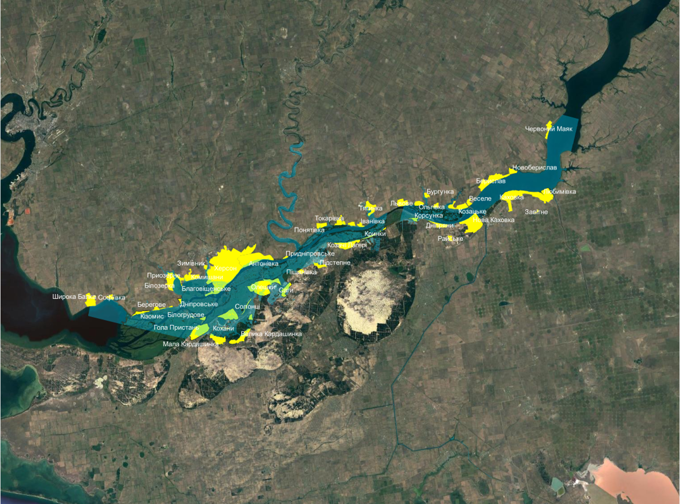
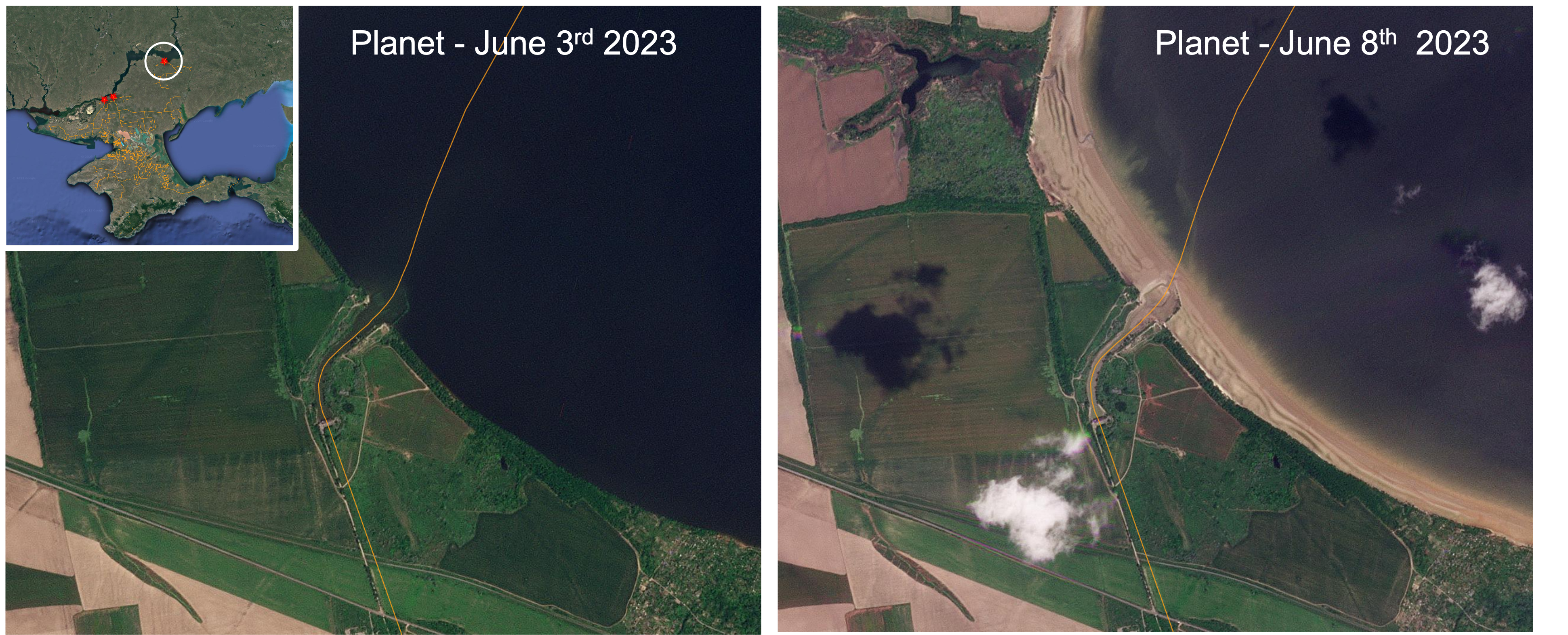
Ukraine’s Kakhovka Hydroelectric Power Plant Dam, located in Russian-occupied Nova Kakhovka in Kherson Oblast, collapsed June 6 following an explosion, flooding the surrounding agricultural land, villages and towns as well as displacing thousands of residents.

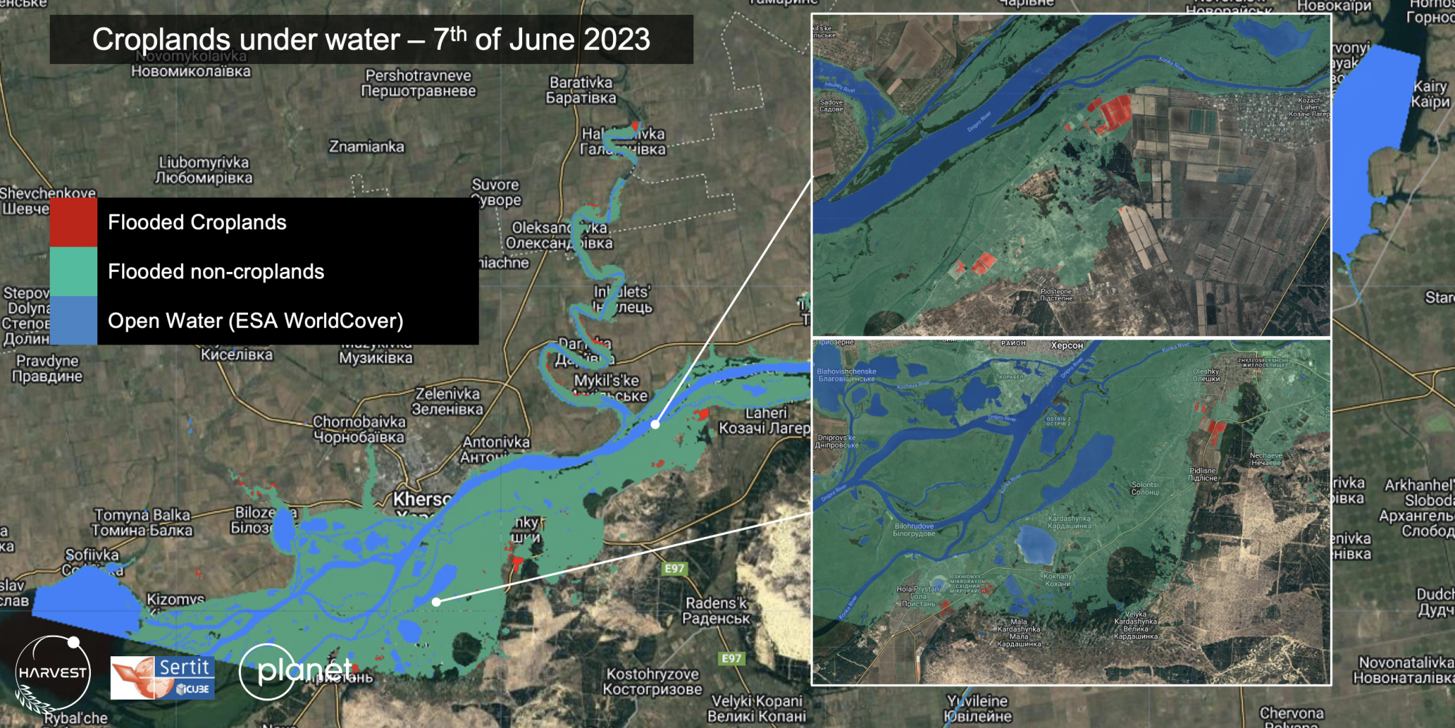
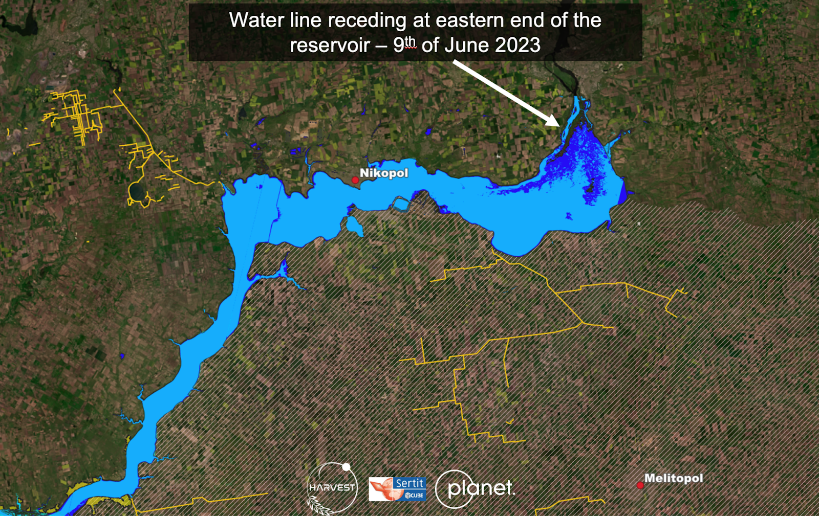
The cause of the explosion is still unclear, as both Russia and Ukraine claim it was caused by the other. The total flooded area is an estimated 410-420 km2, 3.5-5 km2 of which is cropland, according to NASA Harvest, a global food security and agriculture consortium led by NASA and the University of Maryland.

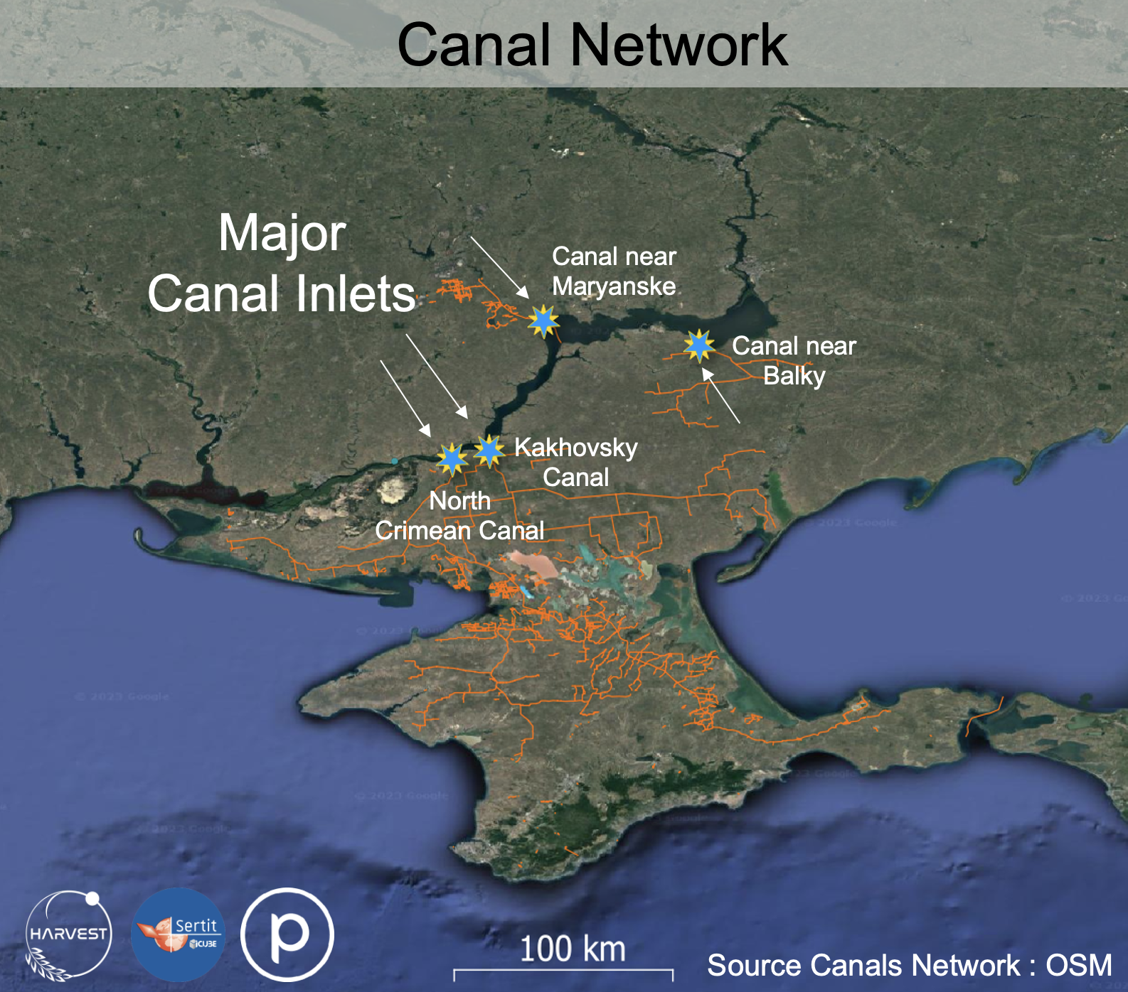
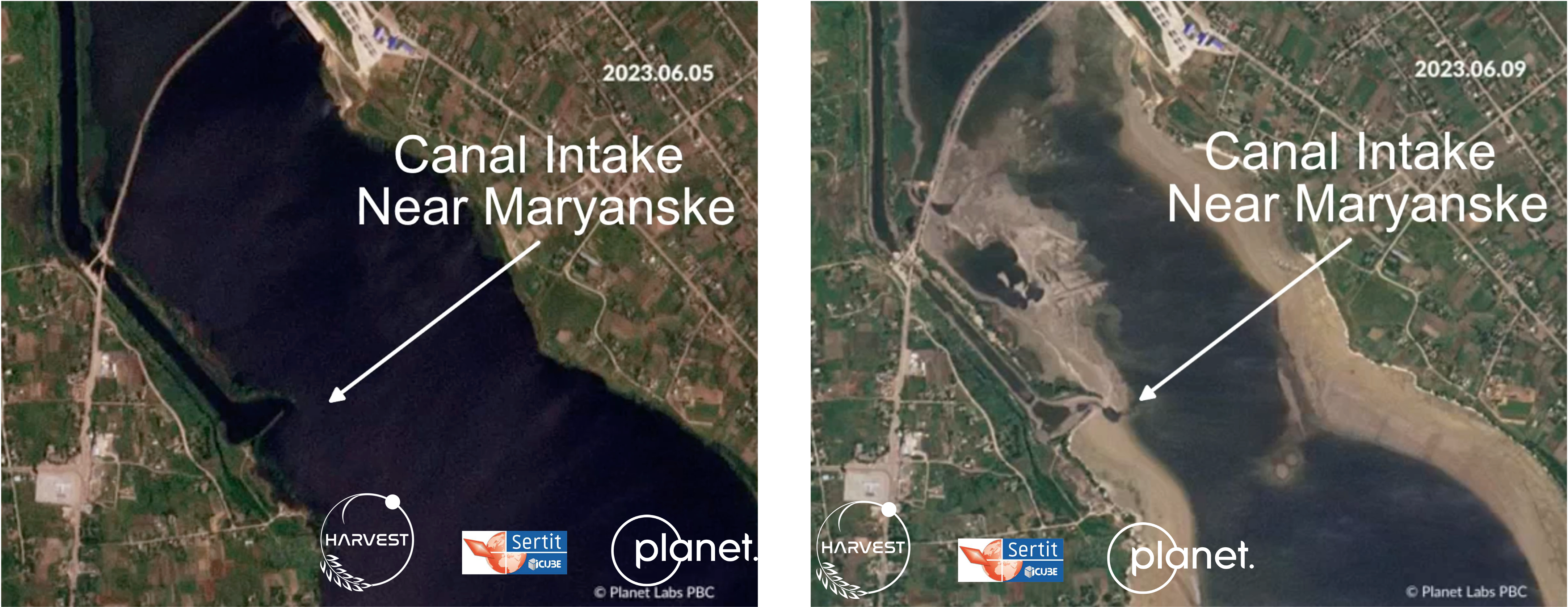
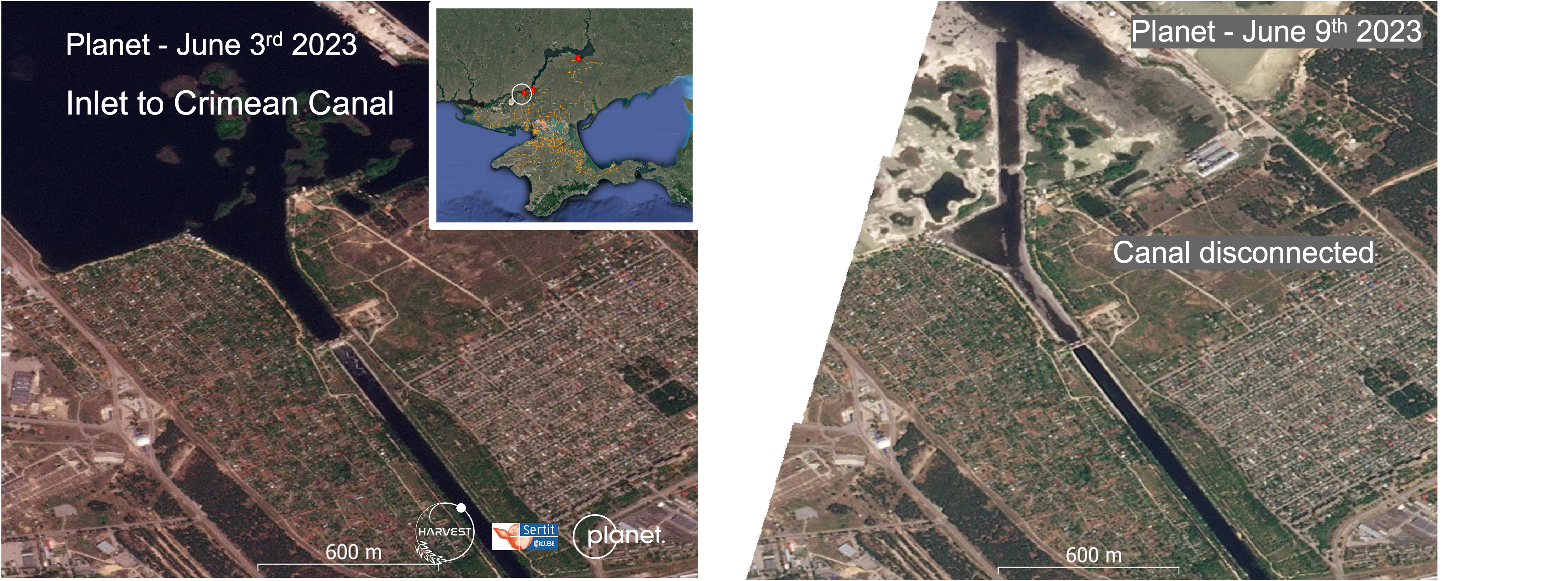
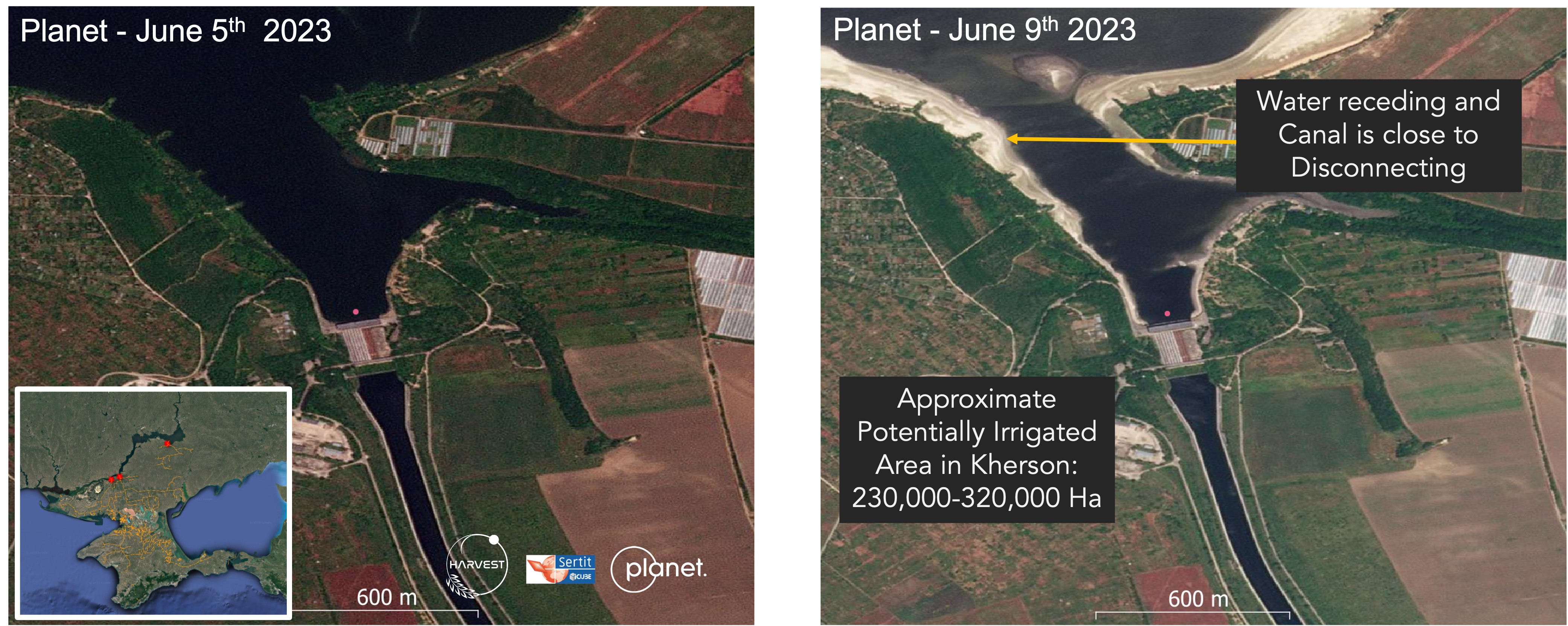
The reservoir that the dam previously held back had supplied water to an estimated 12,000 km of irrigation canals. Combined with the flooded cropland, the now partially disconnected canal system could have concerning implications for food and water security. Additionally, according to a statement from Ukrainian President Volodymyr Zelenskyy's office, the Dnipro River on which the dam sits on has been contaminated with 150 tons of machine oil, a significant environmental concern.  

  • NASA
  • Planet
  • Ukraine_war
Aviation Week Intelligence Network
Monitor the market and connect your business to the people, programs and proprietary data driving the Aerospace & Defense market - only available with AWIN.

ASD_AWIN_thumbnail_270

Stay Connected.
Stay Informed
Grow Your Business.

Learn How

Follow us on

Markets

  • Aerospace
  • Air Transport
  • MRO
  • Defense and Space
  • Business Aviation

Products

  • AWIN Intelligence Bundles
  • Market Briefings
  • Publications
  • Data Services
  • Directories
  • Resources

Contact Us

  • Subscriber Services
  • Advertising, Marketing Services & List Rentals
  • Content Sales
  • Events
  • PR & Communications
  • Content Licensing and Reprints
  • FAQ

Other Resources

  • Aviation Week Marketplace
  • Knowledge Center
  • Newsletters
  • ShowNews
  • Advertising - Media Kits
Copyright © 2025. All rights reserved. Informa Markets, a trading division of Informa PLC.
  • Accessibility
  • Privacy Policy
  • Cookie Policy
  • Terms of Use